Research projects which I participate
Toward a better definition of Pacific-North America Plate Boundary in Central and Southern Baja California, Mexico.
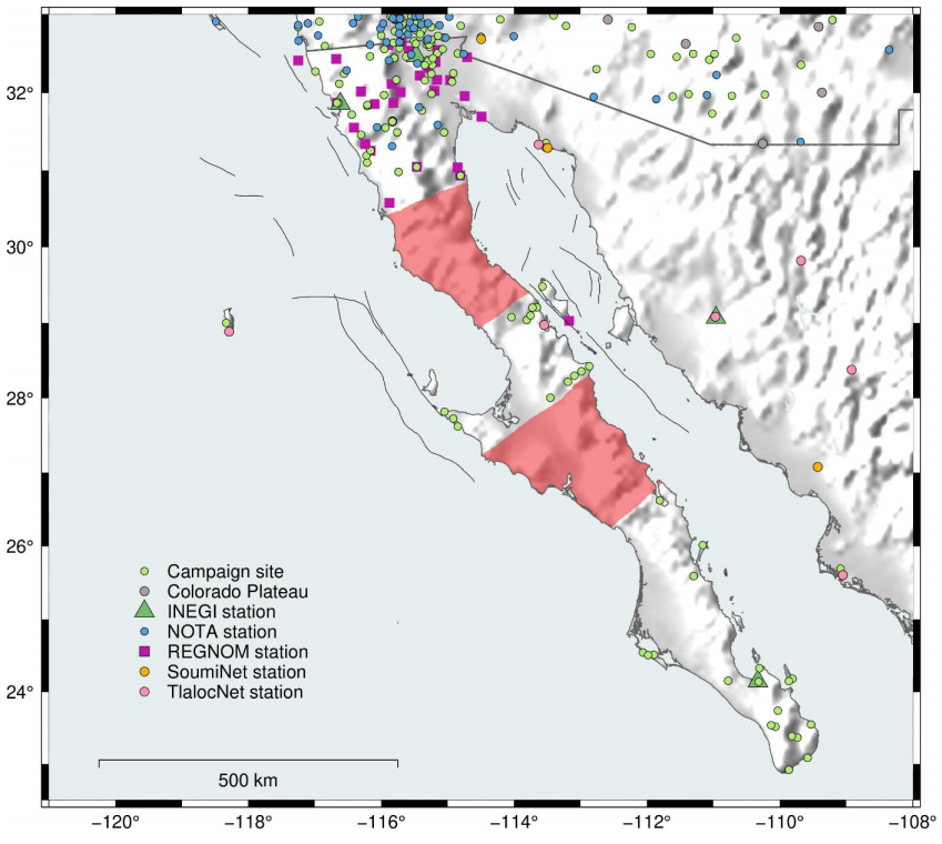
Baja California block is one of the best examples of block translation along a divergent plate boundary. Differences between the motion of Baja California and the Pacific Plate are well-proven due to geological, geophysical and recently space geodetic studies. However, there are discrepancies about the explanation for the rate variation. Since 1994, GPS studies have been applied in the Baja California peninsula, even so, there is a remarkable zone without measurements between latitudes 26.5°N and 30.5°N (excepting ~28-29°N). We think that the optimization of the current geodetic network, measures of previous sites and the installation and observations of new GPS/GNSS sites mainly in the lack data zones, as well as, the application of InSAR measurements in main faults would improve our knowledge about this broad and active plate boundary zone. We seek to constrain the features of Baja California block or “microplate”, to define smaller-size blocks, to study internal deformation, and possibly to observe new patterns of deformation. In general, to provide deeper insights and knowledge about the Pacific-North America plate boundary in Baja California, with its implications for seismic hazard studies.
Figure. Location map showing the distribution of present-day stations (Permanent stations and campaign sites). Based on 1995-2009 campaigns available at UNAVCO Data Archive. REGNOM http://regnom.cicese.mx/, INEGI www.inegi.org.mx; Antonelis et al., 1999, Dixon et al. 2000; 2002; Plattner et al., 2007; 2015; Wetmore et al., 2018). The colored areas represent two areas without GNSS data for geodynamic studies.
NASA Collaborative Proposal: Crustal Deformation Time Series from InSAR and GPS
Two of the top priorities of the Southern California Earthquake Center (SCEC5) are (1) to better understand how faults are loaded across temporal and spatial scales and (2) to establish the role of off-fault inelastic deformation on strain accumulation, dynamic rupture, and radiated seismic energy. Surface crustal velocities and deformation time series are one of the key boundary conditions needed for addressing these problems. Several recent studies have shown that most damaging earthquakes occur in areas where the crustal strain rate exceeds about 50-100 nanostrain/yr [e.g., Kreemer et al., 2014; Elliot et al., 2016.; Zeng et al., 2018]. Many of these areas are heavily populated and have had major destructive earthquakes in the past. Moreover, one of the largest uncertainties of California earthquake hazard models (i.e., UCERF-3 [Field et al., 2014; Field et al., 2015]) is the amount of plate boundary deformation that is accommodated by off-fault strain and whether this strain is accumulating as elastic or as plastic deformation. Therefore, accurate strain rate measurements are needed to improve earthquake forecasts. To achieve an ideal 50-nanostrain/yr accuracy at a 10-km resolution (i.e., a typical fault locking depth) will require a 2-D horizontal velocity model that has an accuracy of 0.5 mm/yr.
Currently GNSS provides this accuracy but not at 10-km spatial resolution; InSAR provides this spatial resolution but cannot yet achieve yet this accuracy. Here we propose a path to achieving this objective using combined GNSS and InSAR. The quality and quantity of GPS and InSAR data are increasing rapidly and many groups are developing detailed crustal deformation models as part of the SCEC Community Geodetic Model (CGM). The overall objectives of the SCEC CGM are to develop a high spatial resolution (~500 m) crustal motion model consisting of velocities and time series for Southern California that leverage the complementary nature of GPS and InSAR observations.
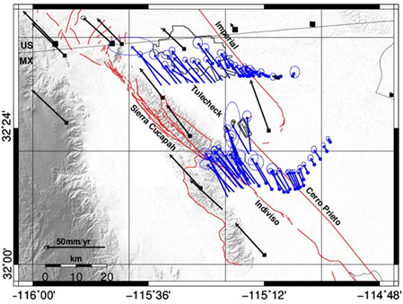
Our proposal has two main components. The first part is to develop InSAR deformation time series using all Sentinel-1 acquisitionsin the SCEC region. This work will be done at JPL and SIO as well as the participants in the Community Geodetic Model (CGM). The second part of our proposed investigation is to continue a campaign GPS and InSAR analysis of the Imperial, Cerro Prieto and nearby faults in the Mexicali region of northern Baja California, MX. This is a collaborative effort between scientists at CICESE and SIO.
Figure: Survey results from GPS field work in Mexicali, Mexico. Preliminary GNSS velocity in northern Baja California in SNARF. Black arrows are continuous GNSS data. Blue arrows are GNSS survey mode data. GNSS measurements across Indiviso and Tulecheck faults are new sites recently survey during this time project.
ALOS-2 geodetic measurements of the subduction zone in Mexico: implications to large earthquakes and seismic hazard
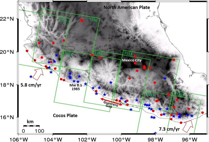
Slow slip events (SSEs) have been observed in most subduction zones with dense geodetic and seismic networks, primarily on the Japan and Cascadia subduction zones. New detailed GPS and Interferometric Synthetic Aperture Radar (InSAR) studies in the Mexican subduction zone are providing additional observations of slow slip phenomena in the Guerrero Gap, which hosted one of the largest SSEs (Mw 7.5) observed to date. Nonetheless, it still remains unclear how SSEs change the stress field in the Guerrero region and what would be the potential implications for future large earthquakes and seismic hazard in Mexico City. This proposal aims to integrate ALOS-2 InSAR time-series analysis and observations from the newly developed continuous GPS/Met network in Mexico (TLALOC Net) to estimate the spatial extent and magnitude of surface deformation, as a baseline reference frame for SSEs and earthquakes on the Mexican subduction zone.
Figure: Tectonic setting of the subduction zone in southern Mexico. Sense of relative motion between Cocos and North American Plates is represented with red outline arrows. Blue starts indicate the historic seismicity, Mw>7.0 since 1911. Red circles denotes permanent GPS stations (TLALOCNet). Green rectangles indicate the coverage of the ALOS-2 radar images.
Postseismic deformation and stress transfer after the 2010 El Mayor-Cucapah (Baja California) earthquake
The 4 April 2010 magnitude (Mw) 7.2 El Mayor-Cucapah earthquake ruptured a series of faults in Baja California, Mexico causing extensive damage in the Mexicali Valley and adjacent areas of southern California, USA. We have been studying the deformation of the Earth’s surface and seismic data to understand which faults moved during the earthquake and how much they moved. This is called coseismic deformation. After the main earthquake, there have been a large number of aftershocks and there is also other ongoing deformation, which is called postseismic deformation.
This postseismic deformation is the response of the Earth’s lithosphere (crust and upper mantle) to the redistribution of stress caused by the large earthquake. The idea is to determine physical properties of the Earth’s crust and upper mantle by comparing the postseismic deformation to models of the geophysical processes involved in the response to large earthquakes. These models can also be used to estimate how stress within the crust and mantle is transferred, both immediately by the earthquake and by the postseismic processes, to faults near the earthquake. Our modeling will enable us to constrain the evolution of crustal stresses, providing important insights for the assessment of future earthquake risk in northwestern Mexico and southwestern USA.
This postseismic deformation is the response of the Earth’s lithosphere (crust and upper mantle) to the redistribution of stress caused by the large earthquake. The idea is to determine physical properties of the Earth’s crust and upper mantle by comparing the postseismic deformation to models of the geophysical processes involved in the response to large earthquakes. These models can also be used to estimate how stress within the crust and mantle is transferred, both immediately by the earthquake and by the postseismic processes, to faults near the earthquake. Our modeling will enable us to constrain the evolution of crustal stresses, providing important insights for the assessment of future earthquake risk in northwestern Mexico and southwestern USA.
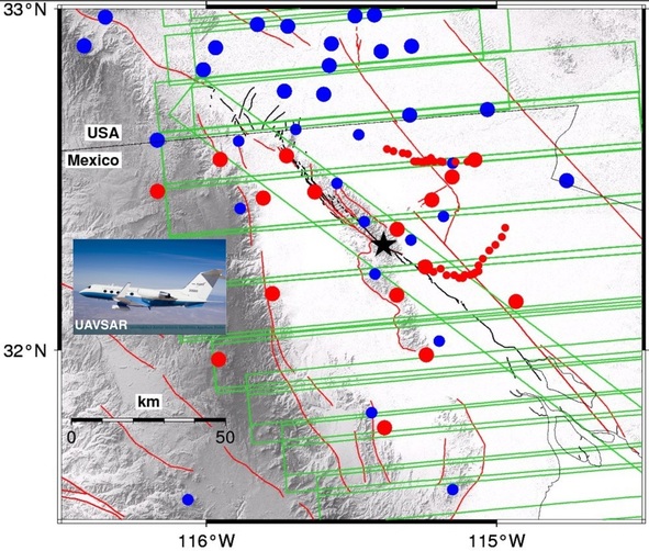
Figure: UAVSAR footprints (green frames) for the El Mayor-Cucapah postseismic study. The figure also includes CGPS (big red and blue dots), as well as, survey GPS sites (small red and blue dots). Inset: C20-A (Gulfstream III) airplane.
NASA has a radar system called Uninhabited Aerial Vehicle Synthetic Aperture Radar (UAVSAR). The UAVSAR system is contained in a pod that was connected to the NASA C20-A (Gulfstream III) piloted airplane for this project. The NASA Gulfstream III has been specially modified to be capable of repeating the same path over the Earth’s surface within a distance of about 5 m, a unique capability that is essential for acquiring data for the InSAR analysis of ground deformation. A key part of the study will combine interferometric synthetic aperture radar (InSAR) analysis of satellite and airborne radar imagery with Global Positioning System (GPS) analysis to estimate the distribution of coseismic fault ruptures, and to measure the postseismic deformation.
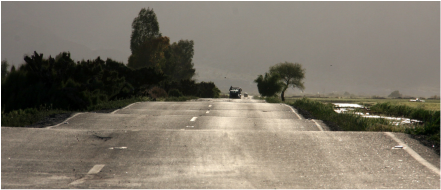
Photo: Alberto de la Hoya.
Sitio con tecnología de Weebly. Administrado por Hosting-Mexico
